| |
Geography and History .Civics Maps
PHYSICAL GEOGRAPHY
GCM01 HEAVENLY BODIES: Showing all the nine Planets & their Natural Satellites, Constellations of the Zodiac symbols. Local Group
of Galaxies, Physical Datas of planets and stars in the Northern and Southern Hemispheres.
GCM02 SOLAR SYSTEM: Showing the Milky Way, Sun & Planets according to size and distances, description of Satellites, Comets and
Meteors
GCM03 EARTH & ITS MOTIONS: Clearly depicting the shape & size of the Earth, the phenomenon of Day & Night, Seasons, Solar &
Lunar Eclipses, Tides, Longitudes & Latitudes, Time Zones etc.
GCMO4 STRUCTURE OF THE EARTH: Density & temperature of Different Earth shells, Behaviour of earthquake waves, folds & faults.
GCM05 ROCKS & MINERALS: Showing rocks related to tectonic plates. Types of Rocks, Composition of Earth's crust, Rock cycle and
types of Minerals.
GCM06 ATMOSPHERE & SPACE: showing Formation, Layers of Atmosphere, Temperature. Pressure and composition of Earth's
atmosphere, Green House effect, Radiation Belt, Distribution of Solar Energy.
GCM07 PRESSURE & WINDS: Showing Pressure zones, Vertical and horizontal Air circulation, Cyclones, Anticyclones, Tropical
cyclones, July and January Monsoons, Pressure belts & Trade Winds.
GCMO8 WEATHER MAP SYMBOLS: Showing the symbols of various types of clouds, Weather and wind conditions. Sea conditions.
GCM09 OCEAN: Showing topography of Ocean floor, Vertical distribution of ocean life. Tsunami, Coastline feature and Map of ocean
currents.
PRACTICAL GEOGRAPHY
GCM10 SURVEYING: Clearly depicting in diagrams & letters. Chain Tape Survey & Plane Table Survey, various instruments required &
the technique.
GCM11 CONVENTIONAL SIGNS: Depicting in diagrams and letters various conventional signs of communications, water bodies,
religious places etc. as shown on maps.
GCM12 MAP PROJECTIONS
. each Rs.100.00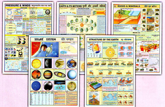 |
|